(ABOVE PHOTO) A stream of lava pouring into the deep ground crack on Monday. Photo by USGS HVO.
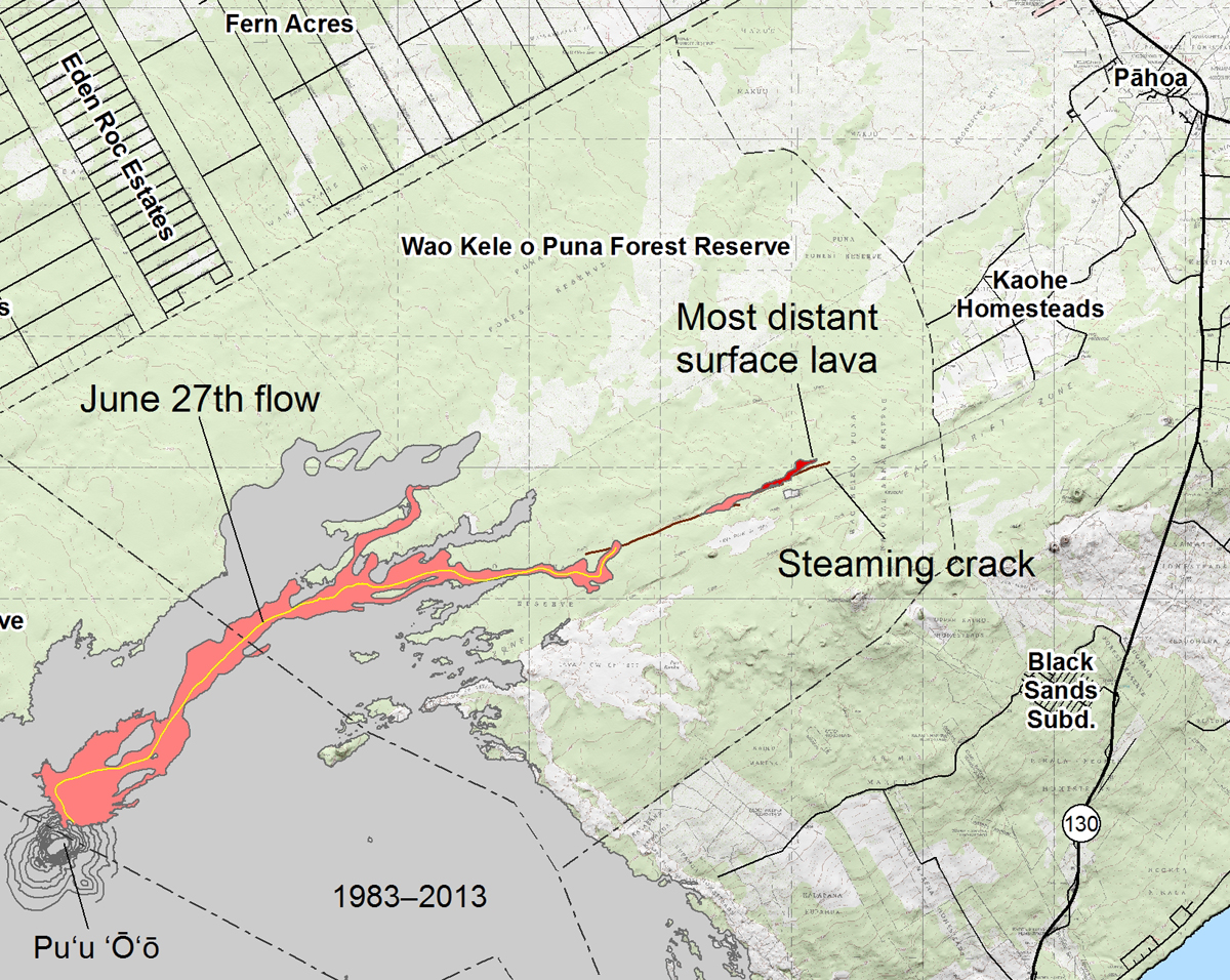
(ABOVE VIDEO) Hawaii County Civil Defense message (Sept. 2) over USGS HVO video, photos and map from Sept. 1.
PUNA, Hawaii – Lava has once again entered a crack in the earth and is advancing underground in the direction of populated areas in Puna.
The hidden flow – given away by a line steam emanating from the crack – infers to scientists that the lava is just over a mile away from leaving the Wao Kele o Puna Forest Reserve and entering lands close to the Kaohe Homesteads subdivision. Emergency officials say the flow does not present with an immediate or imminent threat to area communities.
Here is the Civil Defense message issued Tuesday morning (it can be heard in the video above):

Daily helicopter over flights and assessments of the eruption are continuing. This morning’s assessment showed very little surface activity. The flow had once again entered a crack system yesterday and subsurface activity was noted by the presence of steam. The sub surface flow has advanced approximately 100 yards since yesterday morning.
Presently, the current activities and flow does not present with an immediate or imminent threat to area communities.
The location of the surface flow is approximately 1.2 miles southwest or upslope of the Wao Kele Puna Forest Reserve boundary. Eruption activity will be monitored and additional updates will be provided.
Area residents are encouraged to continue to review their emergency plans in the event conditions change and should an evacuation be necessary. As stated, the current flow activity does not present with an immediate or imminent threat. This update is to keep area residents informed of current observations.
The public is advised that the flow cannot be accessed and is not visible from any public areas. Please do not attempt to access the area as there are many cracks and dense vegetation. In addition please refrain from attempting to do so through the Kaohe Homesteads subdivision and respect the privacy of area residents. Enforcement officers of the State Department of Land and Natural Resources will be conducting patrols and reminding persons in the area of the restricted access.Hawaii County Civil Defense in Sept. 2 message
The USGS Hawaiian Volcano Observatory followed up in their daily Kilauea volcano update:

The June 27th lava flow remains active. At mid-day yesterday, the most distant active lava was 12.6 km (~7.8 miles) from the vent, or about 1.9 km (~1.2 miles) from the eastern boundary of the Wao Kele o Puna Forest Reserve. However, lava a few hundred meters (yards) back from the front was flowing into a large ground crack, where it disappeared from view as it cascaded into the depths. A line of steam, inferred to represent the distance that lava had traveled along the crack, extended east from that spot. The most distant steaming along the crack was 12.8 km (8.0 miles) from the vent and 1.7 km (1.1 miles) from the Forest Reserve boundary.
Small breakouts also remain active closer to Puʻu ʻŌʻō, roughly midway along the length of the June 27th flow. None of these breakouts were very vigorous when observed yesterday, and there was no significant change overnight based on webcam views. Some of these breakouts are also creeping into the forest and producing smoke plumes.USGS Hawaiian Volcano Observatory on Sept. 2

Inset from Sept 1 USGS map

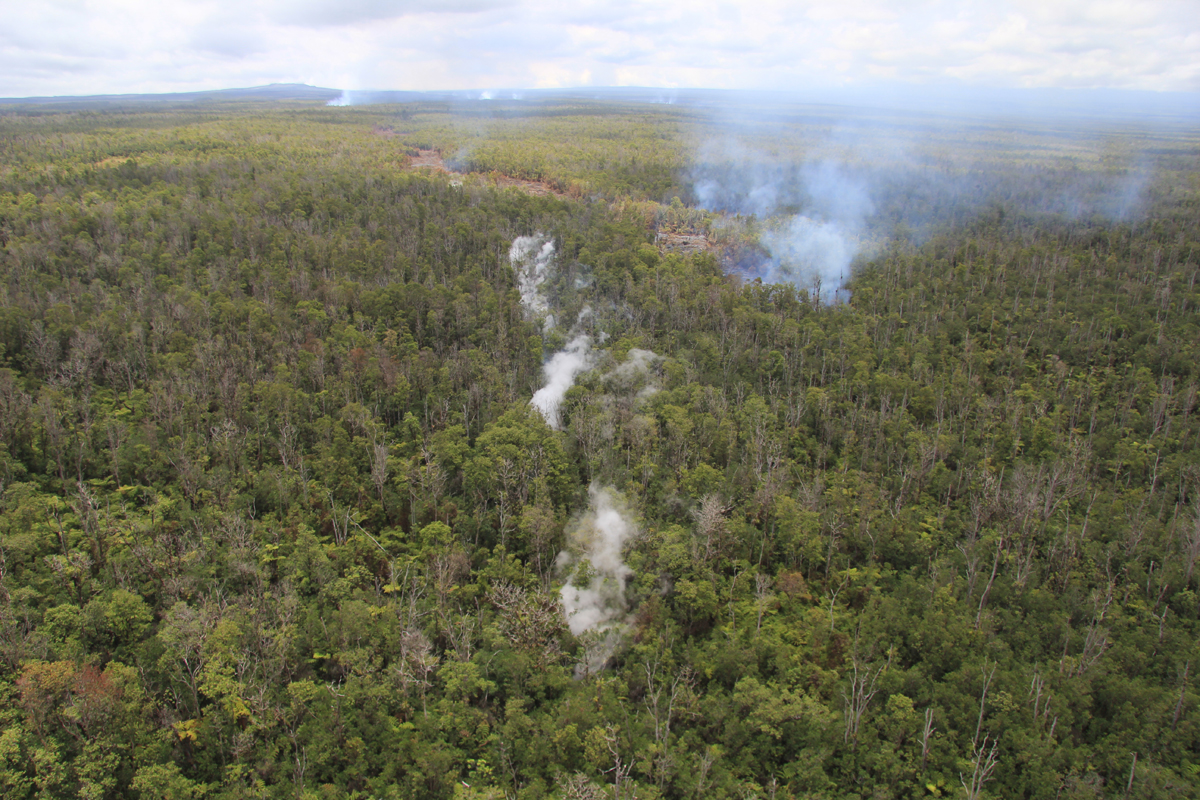
(USGS HVO photo and caption) Extending slightly beyond the lava flows on the surface, a steaming ground crack indicates that lava is continuing to move beneath the surface. The front of the surface flows is just above and to the right of the center point of the photograph, and the steaming ground crack runs along the vertical center line of the photograph. Puʻu ʻŌʻō can be seen on the horizon in the upper left.

by Big Island Video News9:42 am
on at
STORY SUMMARY
Lava is advancing underground in the direction of populated areas in Puna.