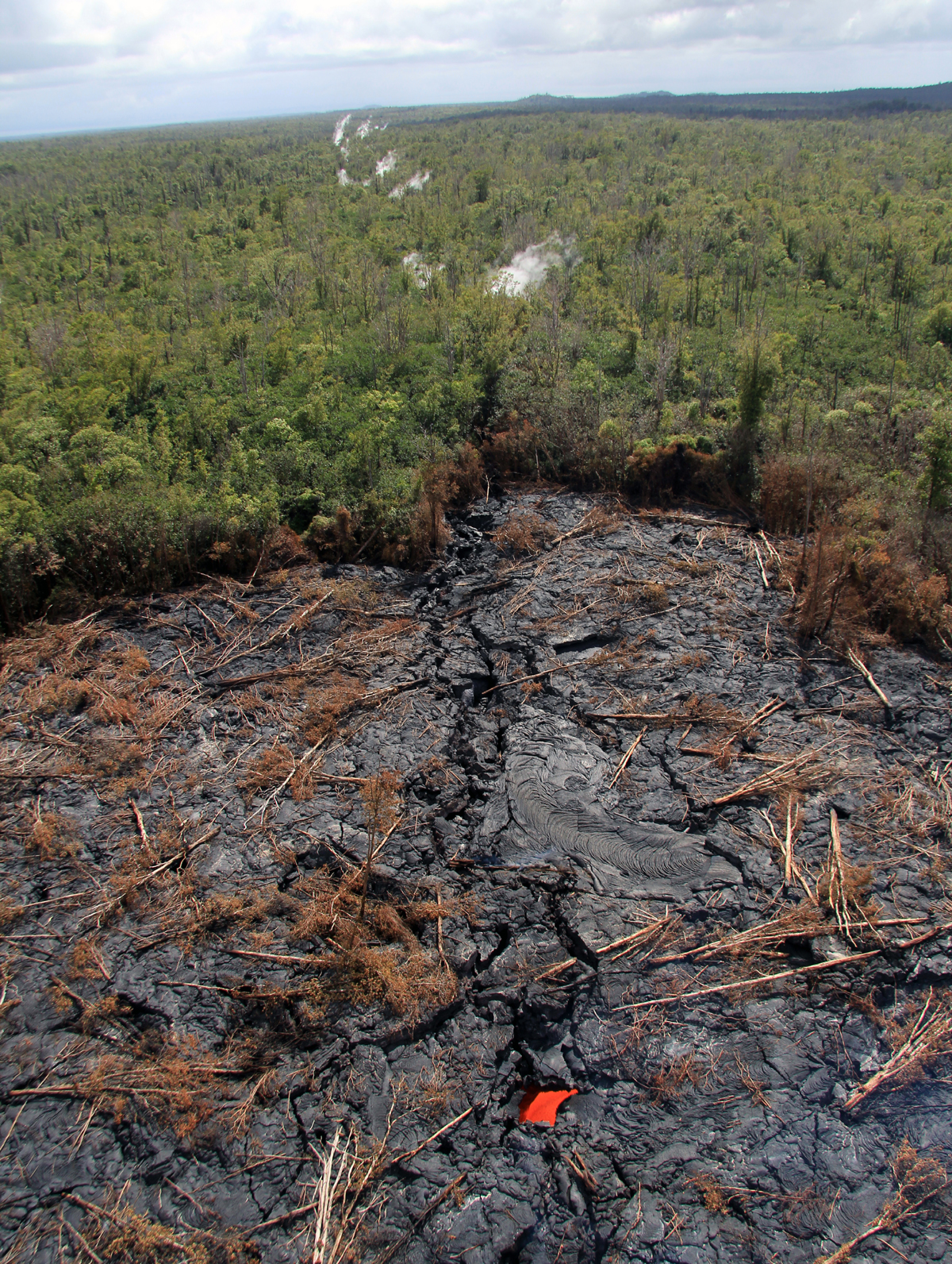
(ABOVE PHOTO) A lava stream fed from the vent on Puʻu ʻŌʻō via a lava tube plunges into a crack. Image courtesy USGS Hawaiian Volcano Observatory.
PUNA, Hawaii – No sooner does Puna begin to regain normalcy in the wake of the destructive Hurricane Iselle, than geologists inform of a lava flow that is of “potential concern” for the recovering district.

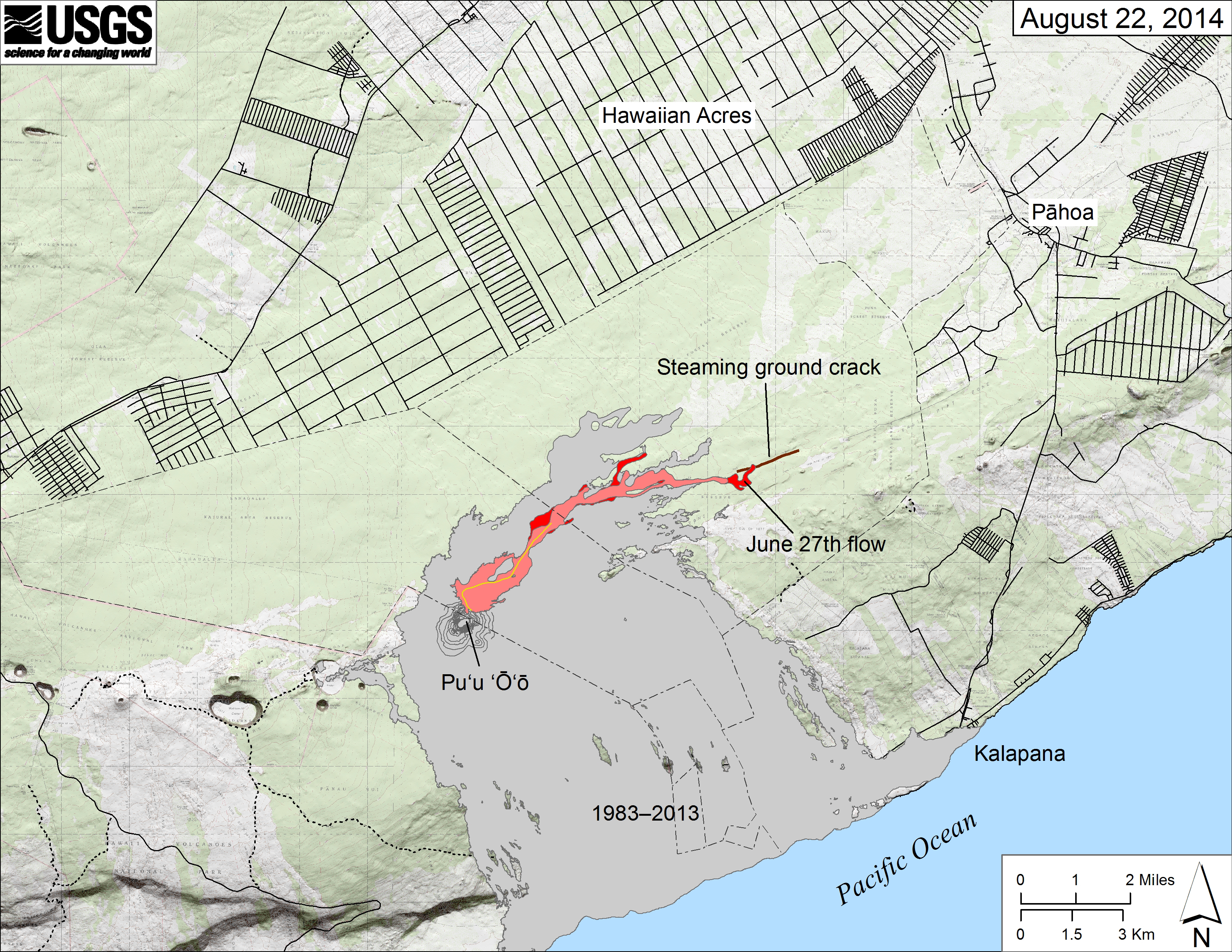
The June 27th lava flow, named for the date it began erupting, continues to advance to the northeast of its vent on the flank of Pu‘u ‘Ō‘ō on Kīlauea Volcano’s East Rift Zone. As of Friday, August 22, the front of the flow was 10.7 km (6.6 mi) northeast of the vent. According to the USGS Hawaiian Volcano Observatory (HVO) Scientist-in-Charge Jim Kauahikaua, the lava flow is not an immediate threat to residential areas or infrastructure downhill of the flow, but could become one in weeks to months if lava continues to advance.USGS Hawaiian Volcano Observatory on Aug. 22, 2104
HVO scientists mapped the flow during an overflight Friday morning. An updated map was posted to the USGS HVO website showing an active flow along two fronts.

Map of June 27th flow in Kilauea’s East Rift Zone, posted on August 22, 2014
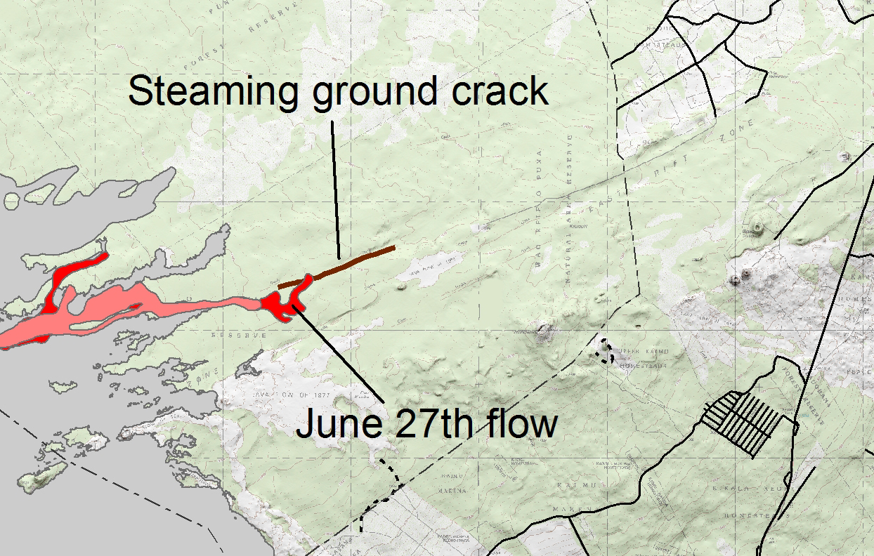
The northern branch was advancing northeastward across fairly flat land, scientists report, while the southern branch had flowed into a ground crack within the rift zone.

Closer look at the lava flow map posted on August 22, 2014. Black Sand Beach subdivision is seen in the lower right of the frame (USGS HVO)
The speed of the lava “underground” does not appear to have slowed it down a great deal.

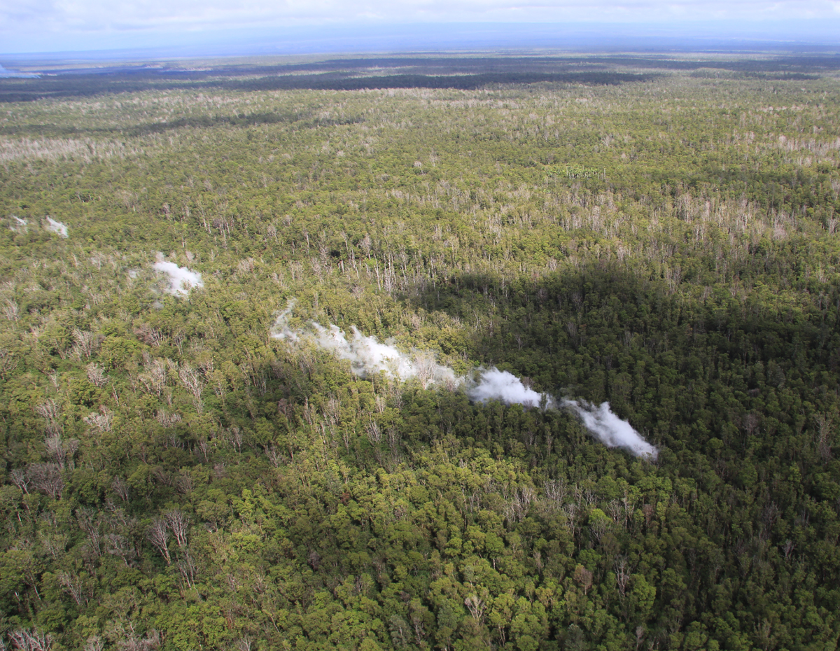
By tracing the steam issuing from the crack, lava is inferred to have advanced 1.4 km (0.9 mi) over the past 4 days, putting it 3.8 km (2.4 mi) from the eastern boundary of the Wao Kele o Puna Forest Reserve. USGS Hawaiian Volcano Observatory on Aug. 22, 2104

A view looking east, near the front of the southern lobe that has entered the crack. Lava is inferred to be present in the deep crack beyond the visible margin of the flow, based on the line of steam sources as well as a vigorous cascade of lava seen in a skylight in the bottom portion of the photo. (USGS HVO)
The June 27th lava flow was initially hailed as a killer of another, slowly advancing lava flow that was also headed towards the northeast. The Kahauale‘a 2 had travelled over 5 miles over the course of several months, when the latest lava flow cut its magma supply and rendered it dead. Since then, however, the new lava flow has gone farther than the Kahauale‘a 2 flow, and it has taken less than one month. Where it goes next is far from an exact science.

The difficulty in forecasting the flow’s exact path is that “downhill of the flow” can be affected by subtle variations in topography (shape and features of the ground surface), changes in lava supply (volume increases or decreases), and where and how lava enters or exits ground cracks along the rift zone.USGS Hawaiian Volcano Observatory on Aug. 22, 2104

Looking west, this photo shows the far end of the steaming that extends out beyond the visible flow margin at the surface. (USGS HVO)
Puna is still recovering from Iselle, which was a Tropical Storm when it landed on Hawaii Island but spent hours churning off shore with the strength of a hurricane. The effects of the storm knocked the volcano observatory off-line, partially. The operation has since recovered.

As of Wednesday afternoon, August 13, all power issues were resolved and the U.S. Geological Survey Hawaiian Volcano Observatory resumed monitoring volcanoes and earthquakes. HVO had been less than fully operational since the previous Friday morning after tropical storm Iselle directly hit the Island of Hawai‘i on August 7. HVO provides continuous, critical updates on the ongoing Kīlauea eruption, earthquake data, and webcam images to emergency managers and island communities for their safety and economic well-being on Aug. 19, 2104USGS Hawaiian Volcano Observatory
One of the first images posted to the observatory website when it regained functionality was a map showing the startling progress of the June 27th lava flow in the six days since the last map was posted, the day before Iselle hit. On Friday, it looked like the vigor of the flow may have been declining. But the Hawaiian Volcano Observatory staff wrote this in the morning Kilauea Status Report:

A helicopter flight yesterday, however, showed that the front of the flow had poured into a very large ground crack and was continuing to advance toward the northeast below ground, thus producing little smoke. The distribution of steam along the ground crack suggested that the flow front was 10.3 km from the vent (straight-line distance) at that time. Another flight is scheduled for today to confirm yesterday’s preliminary finding.USGS Hawaiian Volcano Observatory on Aug. 22, 2104
A few hours later, a media release was issued bearing the title “Kīlauea lava flow northeast of Pu‘u ‘Ō‘ō a potential concern”

Kilauea Volcano’s East Rift Zone eruption began in January 1983. Since then, most lava flows have advanced to the south, reaching the ocean about 75 precent of the time. But the northeastward movement of the June 27th lava flow is not unprecedented. Lava flows also traveled northeast of Pu‘u ‘Ō‘ō episodically in 1983-1986 and for four months in 2007, as well as during the past 19 months. The most distal point reached by the Kahauale‘a and Kahauale‘a 2 lava flows, which were active from early 2013 until June 2014, was 8.8 km (5.5 mi) northeast of Pu‘u ‘Ō‘ō.
The June 27th lava flow is advancing through a heavily forested area on Kīlauea’s East Rift Zone. This area of the rift zone is exceedingly hazardous to hikers as it is highly fractured, with numerous, deep ground cracks that are difficult to see because of the heavy vegetation. Another hazard in the area includes methane explosions that occur when lava flows over vegetated land.
The June 27th lava flow is currently within the Kahauale‘a Natural Area Reserve, which has been closed by the Hawaii State Department of Natural Land and Resources (DLNR) due to the ongoing volcanic hazards, and the Wao Kele o Puna Forest Reserve, also closed by DLNR and the Office of Hawaiian Affairs.USGS Hawaiian Volcano Observatory on Aug. 22, 2104
HVO says it continues to closely monitor the June 27th lava flow through increased overflights, satellite imagery, and webcam images. Scientists are keeping Hawaii County Civil Defense fully informed about the flow’s location.
Meanwhile, the public can track the lava flow activity through maps, photos, and daily eruption updates posted on the HVO website. Should the lava flow become an immediate threat to residential areas or infrastructure, HVO will begin posting more frequent updates.

by Big Island Video News6:49 pm
on at
STORY SUMMARY
Northern branch advancing northeastward across flat land, while southern branch had flowed into a ground crack within the rift zone.