
USGS photo: A closer view of the active flows at the forest boundary, and the numerous plumes of smoke resulting from active lava igniting ʻōhiʻa trees and other vegetation.
PUNA, Hawaii – Geologists are keeping an eye on the Kahauale`a 2 lava flow, which is slowly burning through forest 3.9 miles northeast of Puʻu ʻŌʻō crater.
The lava flow has been active for months, and is still quite a distance from any Puna makai subdivisions. Still, the USGS Hawaiian Volcano Observatory has begun to show the subdivisions on its “Broad scope map of Kīlauea’s ERZ flow field“, showing the creeping lava’s proximity to the nearest neighborhoods. There have been no alerts issued by scientists or emergency authorities in regards to this lava flow.
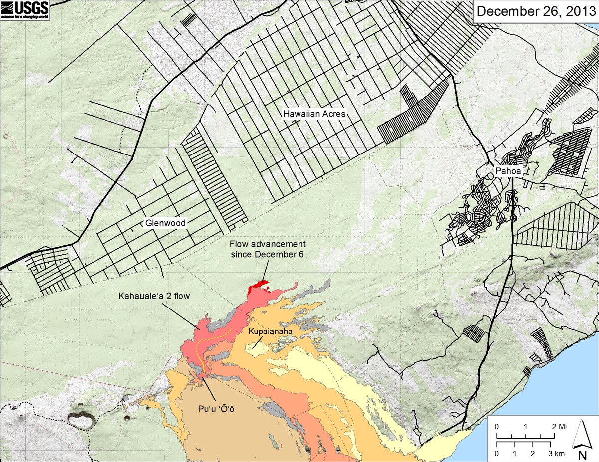
USGS map showing the Kahaualeʻa 2 flow in relation to the eastern part of the Big Island as of December 26, 2013.
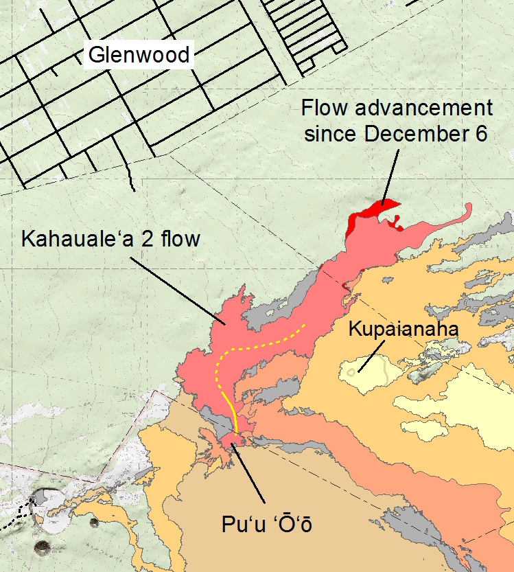
A closer look of the USGS map. The area of the Kahaualeʻa 2 flow as of December 6 is shown in pink, while widening of the flow as of December 26 is shown in red. Older lava flows are distinguished by color: episodes 1–48b flows (1983–1986) are shown in gray; episodes 48c–49 flows (1986–1992) are pale yellow; episodes 50–55 flows (1992–2007) are tan; episodes 58–60 flows (2007–2011) are pale orange, and episode 61 flows (2011–2013) are reddish orange. The active lava tube is shown with a yellow line.
The first Kahauale`a flow to head in the same northeast direction emerged in mid-January from a spatter cone on the edge of the Pu`u `O`o crater floor. It was dead by late April, but a new flow – called Kahauale`a 2 – became active in the same general area in early May. Scientists say in general, activity waxes with inflation and wanes with deflation of the Kilauea volcano.
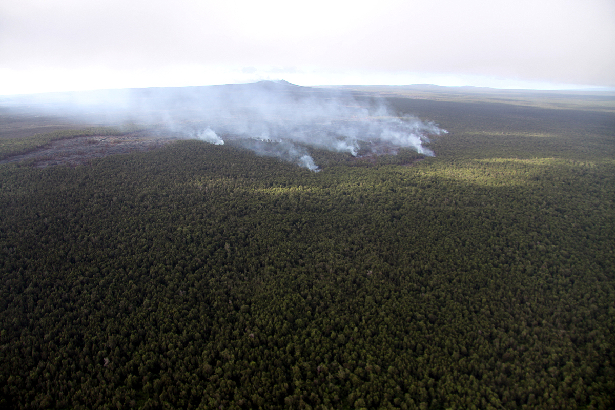
Another USGS view of the Kahaualeʻa 2 flow. Puʻu ʻŌʻō is just left of the center of the photograph in the distance, partially obscured by the smoke.
In Saturday’s USGS HVO Kilauea update, geologists said the new breakout from the upper Kahauale`a 2 lava tube “appeared stalled but inclement weather has prevented many webcam views of this area. When weather permits, distant views of the flow front from the PNcam and R3cam (working intermittently) showed small breakouts and burning forest in several spots.”

by Big Island Video News
on at
STORY SUMMARY
PUNA, Hawaii – Geologists are keeping an eye on the Kahauale`a 2 lava flow, which is slowly burning through forest 3.9 miles northeast of Puʻu ʻŌʻō crater. The lava flow has been active for months, and is still quite a distance from any Puna makai subdivisions. Still, the USGS Hawaiian Volcano Observatory has begun to […]