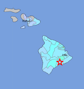
From the USGS “Did You Feel It?” map, showing “light” shaking in blue – associated with no damage – registered around Hawaii Island and Maui, as well.
HAWAII VOLCANOES NATIONAL PARK, Hawaii – A magnitude 4.8 earthquake rumbled beneath Hawaii Island’s Kilauea volcano on Sunday morning at 5:54 a.m. The quake was followed by several aftershocks, the largest of which was a magnitude 3.4 earthquake at 6:06 a.m.
Hawaii County Civil Defense sent out a quick alert on the quake, which was at first measured at a magnitude 4.6, assuring the public that no tsunami was generated as a result.
The USGS “Did you feel it?” Web site received almost 400 felt reports within the first hour of the earthquake.
The event shook a lot of East Hawaii residents out of their Sunday sleep, sending them – where else? – straight to social media sites like Twitter to report the temblor.
https://twitter.com/dcb97/statuses/366588738853273601
https://twitter.com/BigIslandCheese/statuses/366591106466590720
Strong earthquake, 4.6 preliminary magnitude felt in volcano
— Tim O. Bryan (@TBoneBryan) August 11, 2013
#Hawaii #earthquake Nice jolt in Kona at 5:54 am. 4.6 Quake was in HVNP about 90 miles away. A new eruption would be nice.
— lavapix.com (@lavapixcom) August 11, 2013
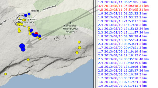
A media release was also issued by the USGS Hawaiian Volcano Observatory. They located the event 5 miles south of the summit of Kilauea Volcano, almost directly below the Kulanaokuaiki campground within Hawaii Volcanoes National Park, at a depth of about 20 miles. HVO posted a map showing the location of the earthquakes on their website.

Isolated close-up of the USGS HVO map showing the location of Sunday’s quakes. The arrows were added by Big Island Video News.
HVO Scientist-in-Charge Jim Kauahikaua said that the earthquakes had no apparent effect on Kilauea’s ongoing eruptions. “HVO monitoring networks have not detected any significant changes in activity at the summits or rift zones of Kilauea or other Hawaiian volcanoes.”
Kauahikaua added that Sunday’s larger quake is only the second earthquake with a magnitude greater than 4 to occur at this location and depth since the start of Kilauea’s ongoing East Rift Zone eruption in 1983. The first one occurred on February 17, 2000. There were six such earthquakes in the 20 years before Kilauea’s ongoing East Rift Zone eruption began, scientists say.
According to Wes Thelen, HVO’s Seismic Network Manager, “These earthquakes were most likely structural adjustments of the Earth’s crust due to the weight of the island on the underlying mantle. The earthquake likely occurred on a near-horizontal fault plane in the mantle, which has hosted earthquakes in this region before. Despite their location near Kilauea’s summit, it’s unlikely that the earthquakes were volcanic in nature due to their depth, which is below, and offset from, the volcano’s known magma plumbing system.”

by Big Island Video News9:33 am
on at
STORY SUMMARY
HAWAII VOLCANOES NATIONAL PARK, Hawaii – A magnitude 4.8 earthquake rumbled beneath Hawaii Island’s Kilauea volcano on Sunday morning at 5:54 a.m. The quake was followed by several aftershocks, the largest of which was a magnitude 3.4 earthquake at 6:06 a.m. Hawaii County Civil Defense sent out a quick alert on the quake, which was […]