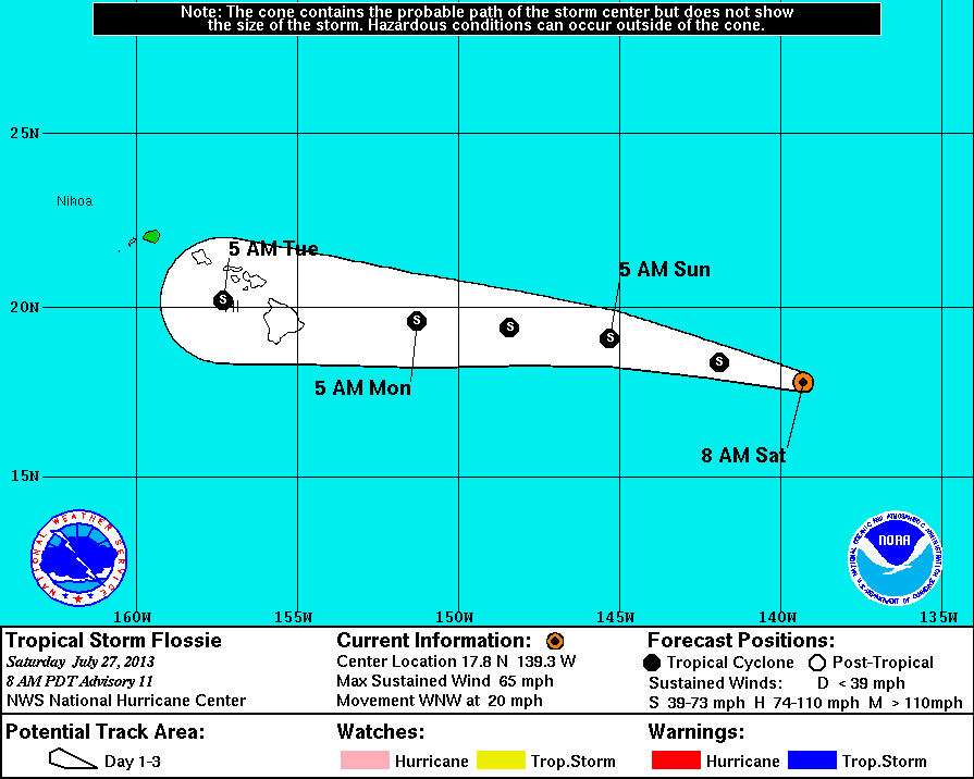
From the National Weather Center: This graphic shows an approximate representation of coastal areas under a hurricane warning (red), hurricane watch (pink), tropical storm warning (blue) and tropical storm watch (yellow). The orange circle indicates the current position of the center of the tropical cyclone. The black line, when selected, and dots show the National Hurricane Center (NHC) forecast track of the center at the times indicated. The dot indicating the forecast center location will be black if the cyclone is forecast to be tropical and will be white with a black outline if the cyclone is forecast to be extratropical. If only an L is displayed, then the system is forecast to be a remnant low. The letter inside the dot indicates the NHC’s forecast intensity for that time: D: Tropical Depression – wind speed less than 39 MPH… S: Tropical Storm – wind speed between 39 MPH and 73 MPH… H: Hurricane – wind speed between 74 MPH and 110 MPH… M: Major Hurricane – wind speed greater than 110 MPH
From the National Weather Center.
 National Weather Service National Weather Service |
|
The Central Pacific Hurricane Center will begin following Flossie from this point on.
As you can see from the weather map below, Hawaii’s chances for Tropical Storm winds have increased a bit. Most of the island now has a %20-%30 percent probability, compared to a %10-%20 percent probability before.
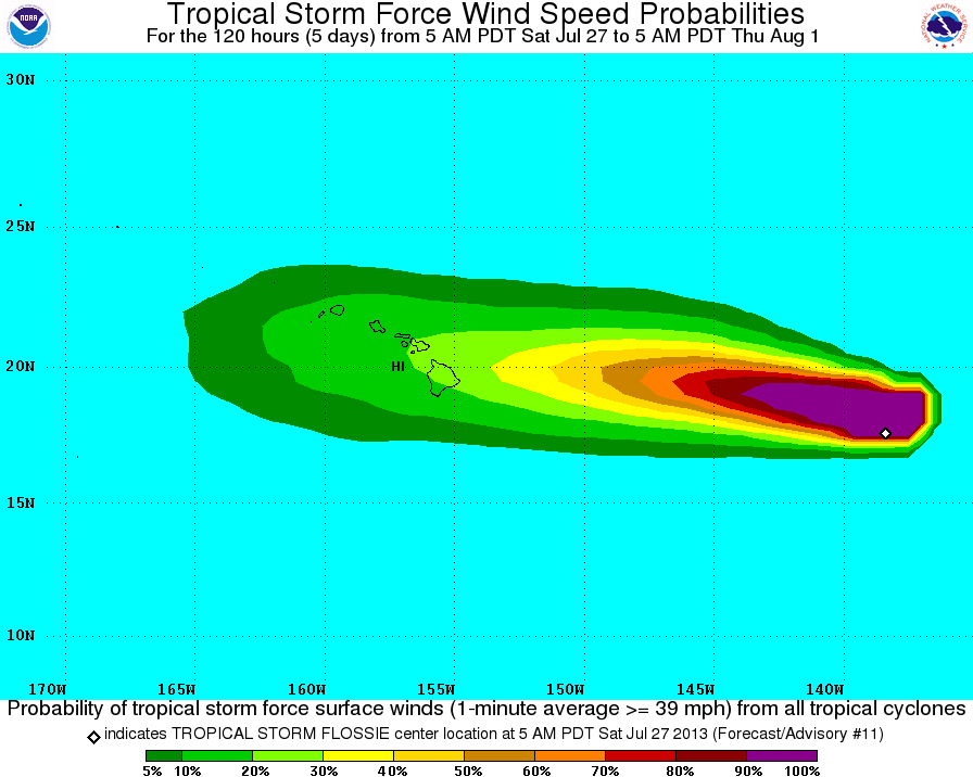
From the NWS: These graphics show probabilities of sustained (1-minute average) surface wind speeds equal to or exceeding 34 kt…39 mph (tropical storm force). These wind speed probability graphics are based on the official National Hurricane Center (NHC) track, intensity, and wind radii forecasts, and on NHC forecast error statistics for those forecast variables during recent years. Each graphic provides cumulative probabilities that wind speeds of at least 39 mph will occur during cumulative time periods at each specific point on the map. The cumulative periods begin at the start of the forecast period and extend through the entire 5-day forecast period at cumulative 12-hour intervals (i.e., 0-12 h, 0-24 h, 0-36 h, … , 0-120 h). An individual graphic is produced for each cumulative interval, and the capability to zoom and animate through the periods is provided. To assess the overall risk of experiencing winds of at least 39 mph at any location, the 120-h graphics are recommended.

by Big Island Video News
on at
STORY SUMMARY
HILO, Hawaii – Tropical Storm Flossie is 1040 miles east of Hilo, and is moving quickly west-northwestward. The storm is still conjuring sustained winds of 65 miles per hour, but the predicted weakening is already being observed by meteorologists. From the National Weather Center. National Weather Service “Satellite images indicate that Flossie has started to […]