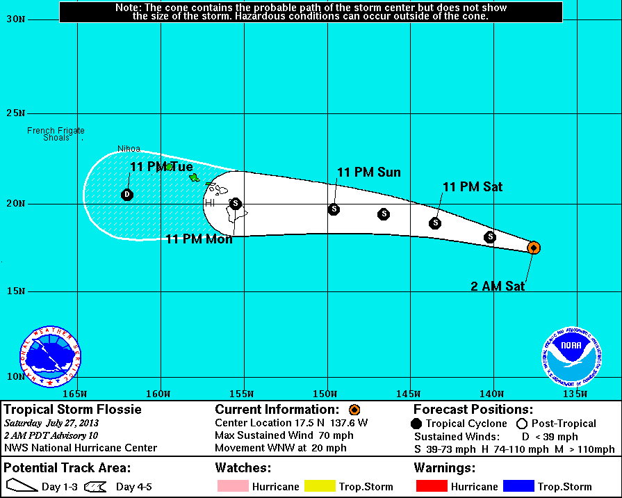
Courtesy National Weather Service: This graphic shows an approximate representation of coastal areas under a hurricane warning (red), hurricane watch (pink), tropical storm warning (blue) and tropical storm watch (yellow). The orange circle indicates the current position of the center of the tropical cyclone. The black line, when selected, and dots show the National Hurricane Center (NHC) forecast track of the center at the times indicated. The dot indicating the forecast center location will be black if the cyclone is forecast to be tropical and will be white with a black outline if the cyclone is forecast to be extratropical. If only an L is displayed, then the system is forecast to be a remnant low. The letter inside the dot indicates the NHC’s forecast intensity for that time:
D: Tropical Depression – wind speed less than 39 MPH
S: Tropical Storm – wind speed between 39 MPH and 73 MPH
H: Hurricane – wind speed between 74 MPH and 110 MPH
M: Major Hurricane – wind speed greater than 110 MPH
HILO, Hawaii – Tropical Storm Flossie is less than 1,155 miles from Hilo and it is picking up steam.
The National Weather Service reports the storm has strengthened since the last report was issued. Now, maximum sustained winds are being measured at 70 miles per hour. Flossie would have to reach 74 mph winds in order to become classified as a hurricane. But the NWS does not foresee the storm gaining more power as it begins to move over cooler waters and drier air, which should weaken the storm.
From the most recent NWS discussion on the storm:
 National Weather Service National Weather Service |
|
Under the scenario described above by the weather service, Flossie would be a weak tropical storm by the time it reaches Hawaii Island.
Although there are presently no coastal watches or warnings in effect, the National Weather Service advises that, “Interests in the Hawaiian Islands should monitor Flossie through the weekend.”

by Big Island Video News
on at
STORY SUMMARY
HILO, Hawaii – Tropical Storm Flossie is less than 1,155 miles from Hilo and it is picking up steam. The National Weather Service reports the storm has strengthened since the last report was issued. Now, maximum sustained winds are being measured at 70 miles per hour. Flossie would have to reach 74 mph winds in […]