By David Corrigan and Tim Bryan
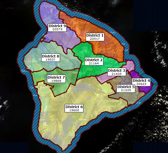
HILO, Hawaii: After months of hard work and hours after hours of public testimony, the Hawaii County Redistricting Commission has come up with a new map, setting the political boundaries for Hawaii County that will last for the next ten years.
The map is still a draft. Two more public hearings will be held before the commission votes to accept the map.
Before the appointed commissioners even began working on a new map, they knew the final map would have to reflect community compromise. The numbers simply wouldn’t allow everyone to get what they wanted.
For example, after lots of talk about Volcano moving out of the Ka’u district to rejoin a Puna district, it never came to pass. As you can see, the final draft map keeps Volcano in District 6. The cut off is just west of Fern Forest. However, Puna residents will be getting something more important to them, as a whole… that is two complete Puna districts… District 4 and 5 will both be comprised entirely of Puna mauka and makai villages and subdivisions.
The Ka’u district stretches all the way up the South Kona coast to include Captain Cook, which is a little further north than the current boundary. At the same time, the South Kona district 7 stretches a little farther north to include more of Kailua Village and the Industrial area.
Folks in Puako and Waikoloa who wanted to stay in the Kohala district will be happy… District 9 will retain those two areas… in their entirety… along with North Kohala and most of Waimea.
Finally, District 1 – the current Hamakua district… appears to have avoided being cut off on the ends. District 1 will still include Honokaa, Ookala, Lauaphoehoe and Pepeekeo… all the way down south to parts of urban Hilo, since the southern boundary now extends over the Wailuku River.
Hilo is losing a district, although District 2 will now take the summit of Mauna Kea, rather than District 1, which is where it is now.
There will be public hearings on the final draft map in Kona on Monday November 21st, and in Hilo on Tuesday the 22nd.
The final map is expected to approved on November 30


by Big Island Video News9:57 am
on at
STORY SUMMARY
By David Corrigan and Tim Bryan HILO, Hawaii: After months of hard work and hours after hours of public testimony, the Hawaii County Redistricting Commission has come up with a new map, setting the political boundaries for Hawaii County that will last for the next ten years. The map is still a draft. Two more […]