HAWAII VOLCANOES NATIONAL PARK, Hawaii: Hawaii Island’s east rift zone has an active lava flow once again, according to Hawaiian Volcano Observatory scientists.
The following media release was just issued:
HAWAI‘I ISLAND, Hawaii — At 2:05 p.m., HST, this afternoon, the USGS Hawaiian Volcano Observatory (HVO) monitoring network detected the onset of rapid deflation of the Pu‘u ‘O‘o crater floor. Soon thereafter, at 2:20 p.m., lava broke out at the base of the west flank of the Pu‘u ‘O‘o cone.
According to Jim Kauahikaua, HVO’s Scientist-in-Charge, the breakout points are 0.7 km (0.4 mi) east of the eastern end of the Kamoamoa fissure that erupted earlier this year, in March 2011, or about half way between Pu‘u ‘O‘o Crater and the eastern end of the Kamoamoa fissure.
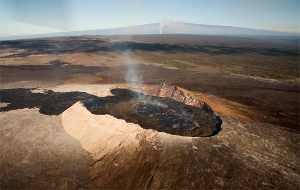
“Interestingly, as the crater floor deflated, lava in the perched lake within Pu‘u ‘O‘o Crater continued to circulate, just as it had over the past several weeks,” Kauahikaua noted, “but, by 3:15 p.m., the crater floor and lava lake began to collapse.”
HVO scientists at the eruption site reported a branched lava flow moving down Kilauea’s south flank. The weaker northwest arm was pushing into kipuka and forest, while the higher volume, larger south arm had advanced at least 3 km (1.8 mi) downslope as of 3:50 p.m. The lava flow is entirely within Hawai‘i Volcanoes National Park and poses no hazard to residents at this time.
The east rift zone activity has not caused significant changes within Kilauea’s summit vent in Halema‘uma‘u Crater.
Updates on the status of Kilauea’s east rift and summit eruptions are posted on HVO’s Web site every morning at http://volcanoes.usgs.gov/hvo/activity/kilaueastatus.php. Additional updates on the new east rift zone activity will be posted each afternoon as merited.
HVO webcam images of Pu‘u ‘Ô‘ô and surrounding area, including the site of the current activity, can be accessed at http://volcanoes.usgs.gov/hvo/cams/. The webcam images, which are updated every 5 minutes, are primarily for research and monitoring purposes, but are made available as a courtesy to the public.
Hawai‘i Volcanoes National Park has closed the Chain of Craters Road until further notice, but sections of Crater Rim Drive remain open. For more information about access and road closures, Park visitors should call 808-985-6011 or email havo_interpretation@nps.gov.
The USGS provides science for a changing world. For more information, visit www.usgs.gov.
Subscribe to USGS News Releases via our electronic mailing list or RSS feed.

Photo above courtesy HVO, taken before the current lava breakout. The photo shows Pu‘u ‘Ō‘ō crater, looking northwest. In addition to flowing out of the crater to the southwest, lava has also been filling in the northeast side of the crater. Lava there is within 6 m (20 ft) of the crater rim. The gas plume from the vent at Kīlauea’s summit is in the background. The gentle slope of Mauna Loa volcano forms the skyline beyond.

by Big Island Video News4:55 pm
on at
STORY SUMMARY
HAWAII VOLCANOES NATIONAL PARK, Hawaii: Hawaii Island’s east rift zone has an active lava flow once again, according to Hawaiian Volcano Observatory scientists. The following media release was just issued: HAWAI‘I ISLAND, Hawaii — At 2:05 p.m., HST, this afternoon, the USGS Hawaiian Volcano Observatory (HVO) monitoring network detected the onset of rapid deflation of […]