(ABOVE) The USGS Hawaiian Volcano Observatory provides this close-up view of an inactive portion of the flow margin. The image shows the irregular surface relief created from pāhoehoe flow inflation, USGS says.
NEWS BRIEFS
- The flow front remains stalled half a mile from Highway 130.
- Brush fires sparked by the lava flow burned over 270 acres yesterday but were contained by Hawaii County fire crews. Civil defense says there is currently no fire threat to area residents or properties.
- Surface activity and widening continues 300 yards upslope from the stalled front.
- A small lobe is expanding towards the north-northeast about 0.4 miles upslope of the stalled front. The USGS Hawaiian Volcano Observatory says the lobe triggered yesterday’s brush fire.
- Two breakouts 1.5 miles upslope remain active, but have not advanced since yesterday. The lobe has entered a drainage area leading to the steepest-descent path that crosses Highway 130 about .6 miles south of the Makuʻu Farmer’s Market.
- Heavy smoke and vog was noted during this morning’s overflight. A southwest wind was again blowing the smoke in a northeast direction over the areas of lower Puna through Hilo.
AUDIO ALERT
This morning’s Hawaii County Civil Defense message (Jan. 13)
LATEST MAPS
USGS Hawaiian Volcano Observatory map (Jan. 13, 2015)
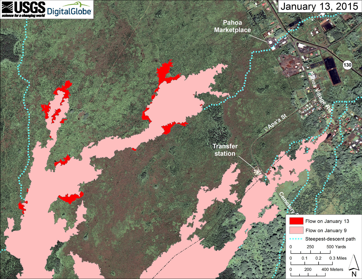
This large-scale map uses a satellite image acquired in March 2014 (provided by Digital Globe) as a base to show the area around the front of Kīlauea’s active East Rift Zone lava flow. The area of the flow on January 9 is shown in pink, while widening and advancement of the flow as determined from our overflight in the morning on January 13 is shown in red. The most distal (Makai) portion of the flow remains inactive while upslope breakouts continue. The front of the north lobe remains active. Overall the activity is sluggish and comprised of scattered breakouts and oozing Pāhoehoe toes.
The blue lines show steepest-descent paths calculated from a 1983 digital elevation model (DEM; for calculation details, see http://pubs.usgs.gov/of/2007/1264/). Steepest-descent path analysis is based on the assumption that the DEM perfectly represents the earth’s surface. DEMs, however, are not perfect, so the blue lines on this map can be used to infer only approximate flow paths.USGS Hawaiian Volcano Observatory on Jan. 13 (HVO maps)
USGS Hawaiian Volcano Observatory map (Jan. 13, 2015)
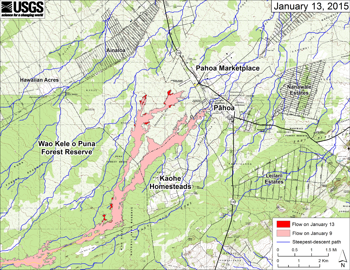
This large-scale map shows the distal part of Kīlauea’s active East Rift Zone lava flow in relation to nearby Puna communities. The area of the flow in the morning on January 9 is shown in pink, while widening and advancement of the flow as determined from our overflight acquired in the morning on January 13 is shown in red.
The blue lines show steepest-descent paths calculated from a 1983 digital elevation model (DEM; for calculation details, see http://pubs.usgs.gov/of/2007/1264/). Steepest-descent path analysis is based on the assumption that the DEM perfectly represents the earth’s surface. DEMs, however, are not perfect, so the blue lines on this map can be used to infer only approximate flow paths. The yellow line marks the active lava tube (the tube continues downslope but has not been mapped).USGS Hawaiian Volcano Observatory on Jan. 13 (HVO maps)
PHOTOS
A brush fire sparked by the lava flow yesterday (Jan. 12) had residents in the nearby Ainaloa subdivision concerned. There were numerous reports of ash falling in the surrounding neighborhoods throughout the day.
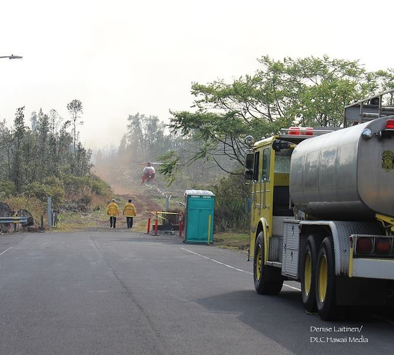
Photo of fire fighting operations taken by Denise Laitinen on Jan. 12
At 17:30 hrs, approximately 270 acres burned within existing fire break. HFD and volunteer units preventing fire from compromising fire break and C-1 used for water bucket operations. 1 dozer being utilized to clean up and improve existing fire break and cut new fire break closer to head of the fire. Hawaii County Fire Department dispatch on Jan. 13
The USGS Hawaiian Volcano Observatory conducted a helicopter overflight yesterday and mapped the perimeter of the June 27 lava flow. Numerous photos were uploaded to the HVO website.
USGS Hawaiian Volcano Observatory photo (Jan. 13, 2015)
USGS Hawaiian Volcano Observatory photos (Jan. 13, 2015)
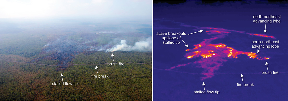
This comparison of a normal photograph and a thermal image shows the position of active breakouts relative to the stalled flow tip. In the thermal image, active breakouts are visible as white and yellow areas. About 700 meters (0.4 miles) upslope of the stalled tip, a small lobe is expanding towards the north-northeast, and had triggered a small brush fire this morning. Breakouts were also active farther upslope, with another north-northeast advancing lobe about 2 km (1.2 miles) upslope of the stalled tip.USGS Hawaiian Volcano Observatory on Jan. 13
USGS Hawaiian Volcano Observatory photo (Jan. 13, 2015)
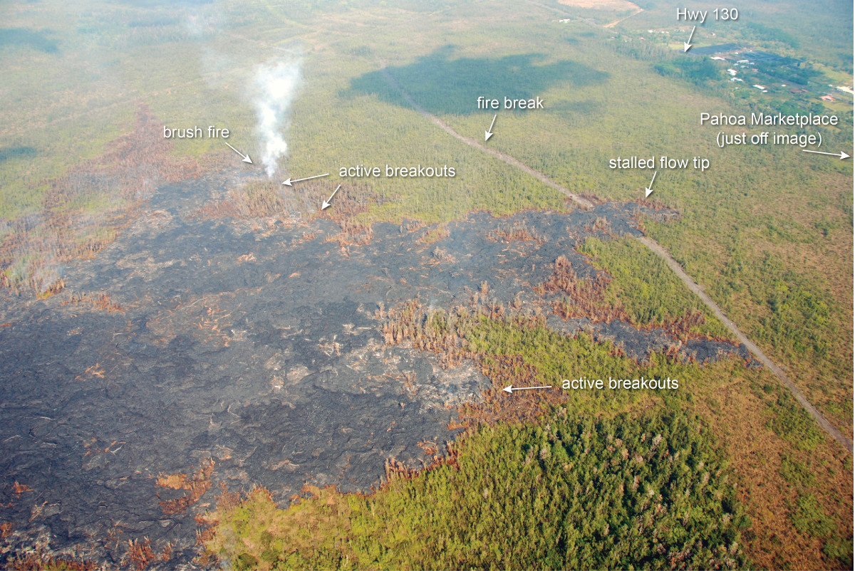
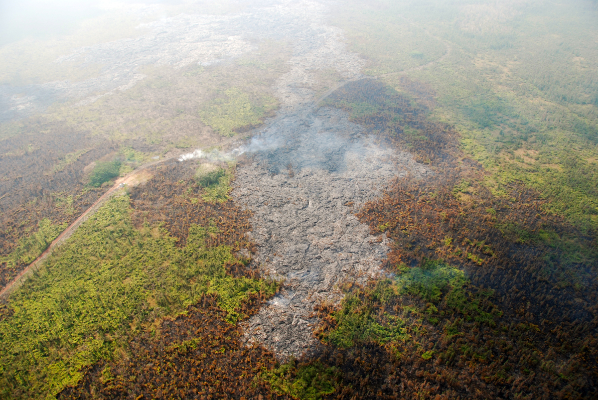
A closer look at the leading edge of the north-northeast advancing lobe that was active about 2 km (1.2 miles) upslope of the stalled flow tip. This lobe has crossed a fire break, and a small brush fire was active along the flow margin.USGS Hawaiian Volcano Observatory on Jan. 13
USGS Hawaiian Volcano Observatory photo (Jan. 13, 2015)
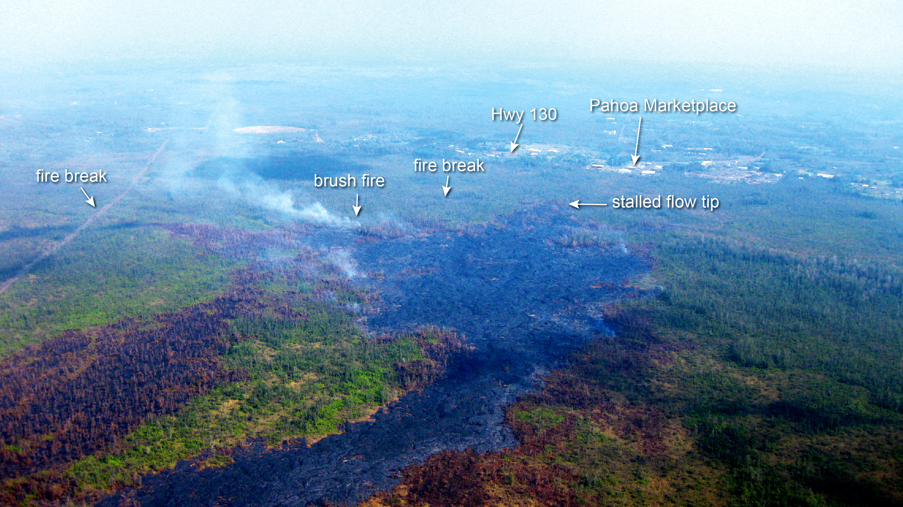
A view of the leading edge of the flow, looking downslope towards Pahoa Marketplace and Highway 130. The brush fire was triggered along the edge of a small north-northeast advancing lobe that was active about 700 meters (0.4 miles) upslope of the stalled flow tip.USGS Hawaiian Volcano Observatory on Jan. 13
USGS Hawaiian Volcano Observatory photo (Jan. 13, 2015)
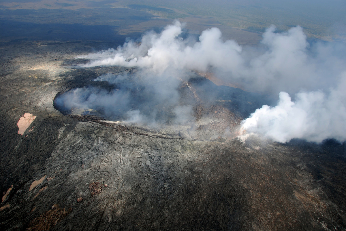
Winds from the south provided a fairly clear view in Puʻu ʻŌʻō crater. At the right side of the photograph, a thick fume source is situated on the northeast rim of the crater.USGS Hawaiian Volcano Observatory on Jan. 13
PRIMARY SOURCES

This morning’s assessment shows that the flow front and south margin breakout remain stalled and there has been no advancement over the past week. The front or leading edge remains 0.5 miles upslope of the Highway 130 and Pahoa Village Road intersection. Some surface activity and widening continues approximately 300 yards above or upslope of the flow front. Two breakouts along the north margin approximately 1-1.5 miles upslope or behind the flow front remain active however have not advanced significantly since yesterday. Other surface breakouts and activity along both margins continues upslope however, and current activity does not pose an immediate threat to area communities. Civil Defense and Hawaiian Volcano Observatory personnel are maintaining close observations of the flow. Residents and businesses down slope will be kept informed of any changes in flow activity, advancement, and status.
The brush fire that started as a result of the lava flow yesterday is contained within the fire breaks and activity is limited to hotspots and smoldering only. Hawaii Fire Department personnel and equipment are on scene and monitoring fire conditions. There is currently no fire threat to area residents or properties.
Smoke and vog conditions were heavy with a southwest wind blowing the smoke in a northeast direction over the areas of lower Puna through Hilo. Smoke conditions may increase in some areas and individuals who may be sensitive or have respiratory problems are advised to take necessary precautions and to remain indoors.
On behalf of the Hawaii County Civil Defense Agency and our partners we would like to thank everyone for your assistance and cooperation. Hawaii County Civil Defense on Jan. 14 at 8:50 a.m. HST

Kīlauea Volcano continues to erupt at its summit and within its East Rift Zone. In the East Rift Zone, the tip of the June 27th lava flow remained stalled; however, active surface breakouts up slope of the front continued. A narrow flow lobe about 2.5 km (1.6 mi) upslope of Pahoa Marketplace continued to advance toward the north-northeast. Another narrow lobe about 700 m (765 yd) upslope of the stalled tip was advancing north-northeast during an HVO overflight yesterday morning.
June 27th Lava Flow Observations: The flow that advanced toward Pahoa Marketplace in past weeks remained stalled approximately 800 m (0.5 miles or 880 yards) from the intersection of Highway 130 and Pāhoa Village Road, however, surface breakouts were scattered between 0.5 and 1 km (0.3 and 0.6 mi) upslope of the stalled flow tip during an HVO overflight yesterday morning. A narrow lobe was advancing north-northeast about 700 m (765 yd) upslope of the stalled tip. This new lobe has advanced about 240 m (260 yd) since January 9.
Additional breakouts were scattered from 1.7 to 3 km upslope of the flow tip, and the long, narrow lobe moving north-northeast in this area was active. This lobe has advanced about 45 m/day (50 yd/day) during the past week. It is in a drainage area leading to the steepest-descent path that crosses Highway 130 about 1 km (0.6 mi) south of the Makuʻu Farmer’s Market, but the flow is still about 3.3 km (2.1 mi) uplsope from Highway 130 (straight-line distance to intersection of highway 130 and steepest descent line) and moving slowly.
Small breakouts were also active in an area of persistent activity in the crack system near the True/Mid-Pacific geothermal well pad about 7 km (4 mi) upslope from Pāhoa; no active breakouts were observed upslope of this area.
Puʻu ʻŌʻō Observations: The tiltmeter on the north flank of Puʻu ʻŌʻō cone continued to record the very weak inflation that has been observed over the past 4+ days. All other monitoring data indicated no significant changes at Puʻu ʻŌʻō. The most recent measurement of sulfur dioxide emissions from all East Rift Zone vents was about 250 tonnes per day on December 19, 2014.
Summit Observations: Very slight inflationary tilt was recorded at the summit since yesterday morning. The summit lava lake displayed minor lava level fluctuations associated with changes in spattering behavior, which are also manifested as variations in tremor amplitudes and gas release. Small amounts of particulate material were carried aloft by the plume. The average emission rate of sulfur dioxide was around 5,400 tonnes/day for the week ending on January 6.USGS Hawaiian Volcano Observatory on Jan. 14 at 9:17 a.m. HST

by Big Island Video News9:10 am
on at
STORY SUMMARY
The front remains stalled, the brush fire is contained, and new imagery shows lots of activity on the flow.