(ABOVE VIDEO) This evening’s Civil Defense message with video from a Dec. 31 overflight courtesy Mick Kalber.
NEWS BRIEFS
- The flow front has decreased in activity and has not advanced since yesterday. It is still .5 miles upslope of the Highway 130 and Pahoa Village Road intersection and approximately 660 yards from the Pahoa Market Place complex.
- The county reports the public access lava viewing at the Pahoa Transfer Station will be closed tomorrow, Thursday January 1st and reopen for normal viewing access on Friday January 2nd.
PRIMARY SOURCES

This afternoon’s assessment shows that the flow front has decreased in activity and has not advanced since yesterday. The front or leading edge remains .5 miles upslope of the Highway 130 and Pahoa Village Road intersection and approximately 660 yards from the Pahoa Market Place complex. The surface breakouts and activity along both margins continues upslope of the front however, current activity does not pose an immediate threat to area communities. Civil Defense and Hawaiian Volcano Observatory personnel are maintaining close observations of the flow. Residents and businesses down slope will be kept informed of any changes in flow activity, advancement, and status.
The public access lava viewing at the Pahoa Transfer Station will be closed tomorrow, Thursday January 1st and reopen for normal viewing access on Friday January 2nd. We apologize for any inconvenience this may cause.
The public is reminded that the viewing area opens at 8:00am and closes promptly at 6:00pm.
On behalf of the Hawaii County Civil Defense Agency and our partners we would like to thank everyone for your assistance and cooperation and wish everyone a safe and happy New Year. Hawaii County Civil Defense on Dec. 31 at 5 p.m. HST


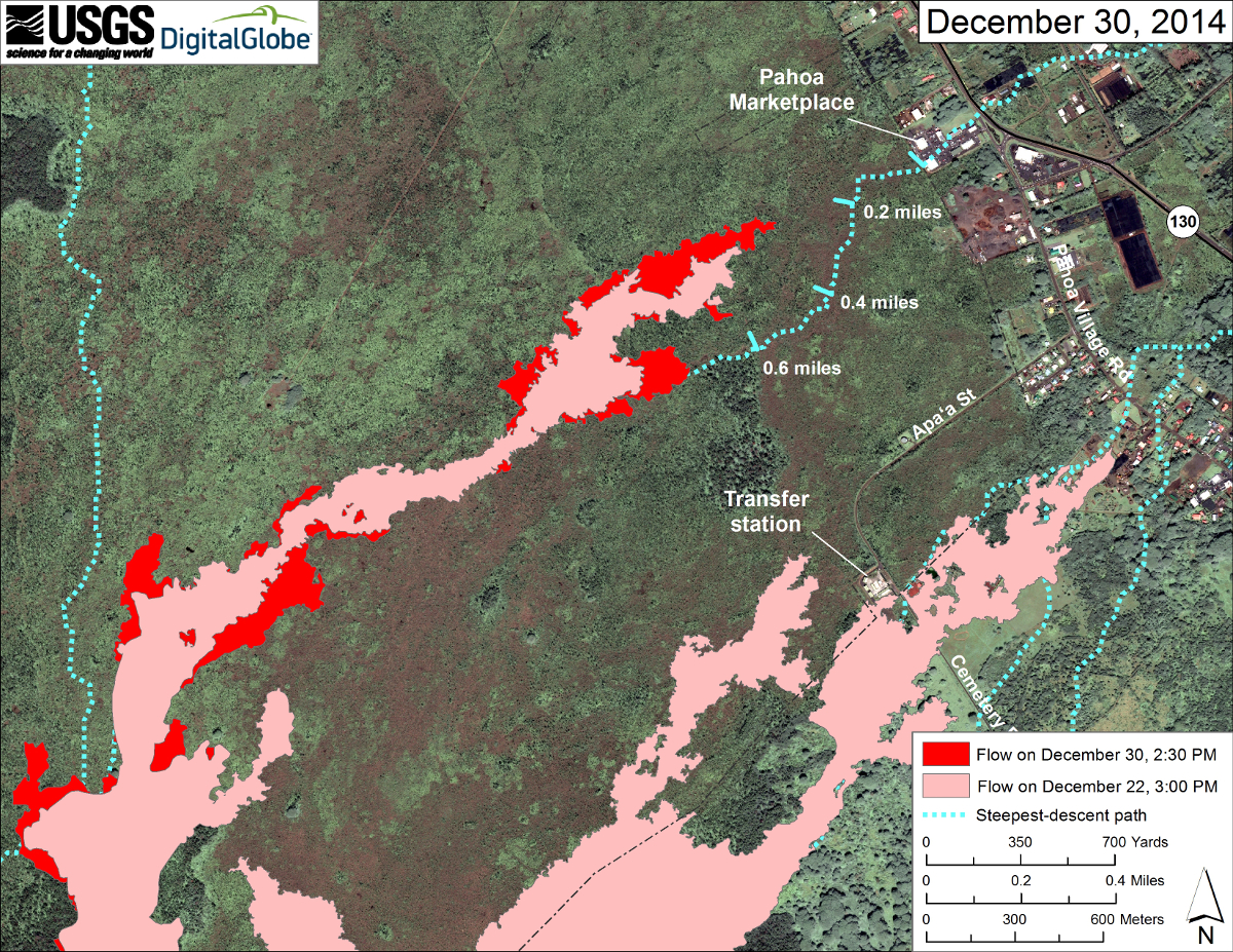
This large-scale USGS map uses a satellite image acquired in March 2014 (provided by Digital Globe) as a base to show the area around the front of Kīlauea’s active East Rift Zone lava flow. The area of the flow on December 22 at 3:00 PM is shown in pink, while widening and advancement of the flow as mapped on December 30 at 2:30 PM is shown in red.
The downslope tip of the flow was stalled about 530 m (580 yards) upslope from the Pahoa Marketplace at 19.498695 , -154.969467 (Decimal Degrees ), but weak activity was present about 50 m (55 yards) behind the front. Other small breakouts were sparsely scattered across the flow up to about 3 km (2 miles) upslope from the stalled tip (and others even farther upslope), but most of the activity was concentrated along the leading 1 km (0.6 miles) of the flow. This differs from the previous few weeks and is not an increase in activity near the flow front, but rather a decrease in activity farther upslope.

by Big Island Video News7:08 pm
on at
STORY SUMMARY
The flow front has decreased in activity and has not advanced since yesterday.